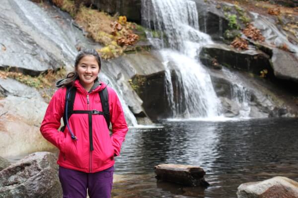
If you’re looking to experience a Yosemite waterfall off the beaten path, Carlon Falls is for you. Situated just outside of park gates, you can hike into the Yosemite wilderness and never pay any entrance fees. This isn’t the biggest, or even the most impressive. If you just like chasing waterfalls, you’ll like Carlon Falls.
Hiking
Hike: Wapama Falls & Rancheria Falls
Where: Yosemite National Park
Trailhead: O’Shaughnessy Dam
Level: Moderate
Duration: 5.5 hours
Length: 13 miles out and back
Gear: Icebreaker Tech T Lite, Triple Aught Design Artemis Hoodie, REI Sahara pants, Outdoor Research Essence Leggings, JepPaks pack, Black Diamond Ultra Distance trekking poles, and Salewa Alp Trainer Mid GTX boots
Cost of Parking: Free
Hetch Hetchy Valley was once a mirror image of Yosemite Valley; now it’s a reservoir providing millions of San Francisco Bay Area residents like myself water. Despite this, Yosemite’s counterpart is still a wondrous sight to behold, and lacking in the millions of visitors Yosemite Valley receives.
Only have a day in Yosemite Valley? Head up to Glacier Point via Four Mile Trail to get the best bang for your buck. Unparalleled views of Yosemite Valley, front row seats to Half Dome and beyond await you at this magical spot.
Hike: Freel Peak
Where: Lake Tahoe Basin
Trailhead: Trout Creek, at the end of Oneidas St.
Level: Strenuous
Duration: 7 hours
Length: 7 miles?
Gear: Outdoor Research Cathode Vest, Outdoor Research Mainstay Beanie, Icebreaker BodyFit 200 Oasis Crew Long-Sleeve, NW Alpine Gear Black Spyder Hoody, REI Sahara pants, Arc’teryx Alpha SL Hybrid jacket, Boreas Topaz 25 pack, Black Diamond Ultra Distance trekking poles, and Salewa Alp Trainer Mid GTX boots
Cost of Parking: Free
On my quest to get OGUL recognition, I decided to tackle Freel Peak, the tallest peak in El Dorado County and in the Lake Tahoe Basin. I opted not to begin at Horse Meadow; I wasn’t sure that my car could handle the gnarly Forest Service roads. Instead, I began at Trout Creek, at the end of Oneidas St. and fully paved up to the trailhead.
Fresh from sea level and running on about 6.5 hours of sleep, the beastly David Wherry and I set off with a friend on a Friday morning to acclimatize for our Whitney hike back in September. Our destination was Meysan Lake at approximately 11,500′. The trail begins at the Whitney Portal Family Campground by the summer homes, a short walk across Lone Pine Creek from our campsite. Starting elevation is 8360′, so if you’re not used to the altitude, expect to be huffing and puffing.